IGCP Project 559
Crustal Architecture and Images

contact us: [email protected] | about us
|
IGCP Project 559
Crustal Architecture and Images |
|
|
contact us: [email protected] | about us
|
34th International
|
Updated: Oct 13, 2010 IGCP Project 559 - Seismic ImagesCrustal Images From The Northeast Tibetan Plateau, Central ChinaCompiled by Doug Finlayson from information supplied by Songlin Li, Walter D. Mooney, and Guozhe Zhao
Location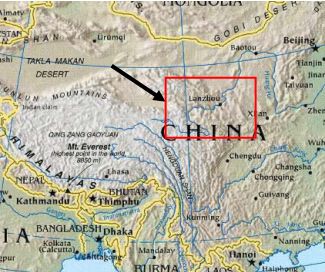
Fig. 1 - Location map.
Tectonic Setting – Continent -Scale Dextral Shear ZoneNowhere else on Earth is there a tectonic situation like that on the northeast margin of the elevated Tibetan Plateau where it is impacting on the cratons of central Asia in a process called"tectonic escape". The northward-moving Tibetan Plateau is, in effect, squeezing the cratons of northern China eastwards and, in the process, creating a series of continental-scale sinistral (left-lateral) shear zones. Other Tectonic AnaloguesThe tectonic setting and tectonic escape mechanism applying at the northeast margin of the Tibetan Plateau is unique on planet Earth. However, there are other examples of continental-scale strike slip faulting, e.g. in Turkey where strike-slip faulting on the Anatolian Fault is active along the southern margin of the Black Sea and has caused numerous large damaging earthquakes. 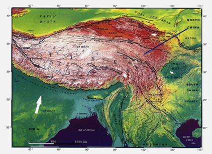
Fig. 2 – Shear zones of central China and the location of Profile 973 Geological Era/Period
The Tibetan Plateau is a collage of continental fragments that were added successively to the Eurasian plate during the Palaeozoic and Mesozoic eras. From north to south, the main Tibetan crustal blocks are the Kunlun , Songban-Ganzi, Qiangtang, and Lhasa terranes. The plateau is underlain by continental crust about 65 km thick, compared with more usual thicknesses of about 30-35 km. Uplift of the plateau began in the early Miocene and it probably reached its present elevation by about 8 Ma (million years before present). Various theories have been proposed for the origin of this immense thickness including basement reactivation (involving the distributed shortening of the Plateau by folding and thrusting), continental subduction (entailing the wholesale underthrusting of the Indian continental crust beneath the Tibetan Plateau and subsequent uplift) and the introduction of Indian crust beneath Tibet as melt (Wilson, 2002; Alsdorf et al, 1998). Deep seismic reflection profiling in southern Tibet on the border with Nepal indicates a dramatic thickening of the crust northwards from 55km near the Nepalese border to about 75 km under the Lhasa Terrane (Hauck et al., 1998). Global Positioning System (GPS) measurements in the northeast Tibetan Plateau region of study for this paper indicate the plateau is moving north-northeast to northeast relative to the South China Block at a rate of 11-19 mm/year (Chen et al., 2000). Global And Societal SignificanceThe northeastern margin of the Tibetan Plateau is a quasi-triple junction of three lithospheric "blocks" – the Qinling-Qilian Terrane of the Tibetan Plateau in the southwest, Ordos Basin on the western margin of the Sino-Korean Craton in the east, and Alxa Fold Belt in the northwest. This region has experienced some of the largest intra-plate earthquakes ever documented. In one small triangular-shaped region of interest there have been a number of earthquakes with magnitudes above 8 , including the 1920 M=8.6 Haiyuan earthquake (the largest in China in recent times), the 1927 M=8 Gulang earthquake and the 1739 M=8 Yinchun earthquake (Fig. 3). 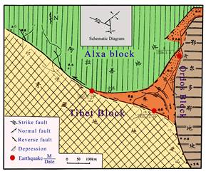
Fig.3 – Simplified tectonic setting of the triangular study area on the northeast margin of the Tibetan Plateau. Geodynamic models for the region indicate that the Tibetan Plateau is compressing the adjacent blocks northward and eastward resulting in a series of major active faults e.g. the Kunlun Fault, the Haiyuan Fault and the Qinling Fault, all with left-lateral movements of 10-20 mm/year. The 2001 Kunlun Pass earthquake (Ms = 8.1) (Fig. 4) had a surface rupture of 350-426km. In the region of interest on the northeast margin of the Tibet Plateau, the crust is deforming significantly within the Qinling-Qilian Terrane, while the Ordos and Alxa "blocks" to the northeast and northwest respectively are apparently reacting as passive rigid units. 
Fig. 4 – Location of the 2001 Kunlun Pass earthquake (Ms = 8.1) The total surface rupture was 350-426 km (dextral shear). The earthquake damaged significant engineered structures including the Qinghai-Tibetan Highway , bridges, railways, pipelines and tunnels. Left-lateral displacements were up to 7.6 m in places) (Song Ruixiang, 2002). The Tibet Plateau is very active seismically and is strongly compressing the adjacent blocks northward and eastward, while the Ordos Block and Alxa Block are passive. The lithosphere of the Tibet Plateau is soft with low density, while the Ordos and Alxa Blocks are quite solid with a high density lithosphere. Thus, an important question with regard to a better understanding of the large earthquakes in the region is to determine a model for what happens when the active but soft Tibet Plateau compresses the passive but solid Ordos and Alxa Blocks. To do that an improved knowledge of the Earth's crust and mantle in the region is needed. 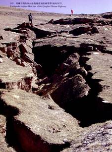
Fig. 5 – Part of the surface rupture resulting from the 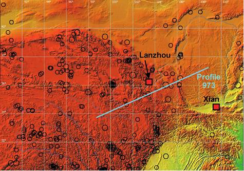
Fig 6 – Major earthquakes on the northeast margin of the 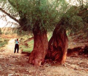
Fig. 7 – Tree split in half by strike-slip faulting in central China. Seismic Images of the Earth's CrustWide-angle seismic profiling - Project 973Because of the magnitude and frequency of major earthquakes within the deformational zone on the north-eastern margin of the Tibetan Plateau and the potential for major infrastructure damage, the Earth's crust in the region was the focus of intensive study by the China Seismological Bureau ("Project 973"). Phase one of the project conducted wide-angle seismic profiling along a 1000-km transect (Fig. 8). The transect region was also the focus of teleseismic observations (from distant earthquakes), and magneto-telluric sounding. 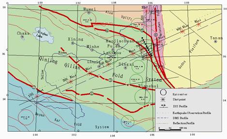
Fig. 8 – Location of wide-angle deep seismic profiling on the northeast Tibetan Plateau margin. 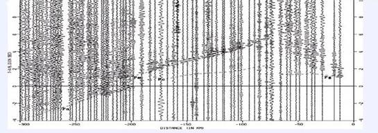
Fig. 9 – Wide-angle seismic record section from a shot within the Ordos Block recorded at stations to the southwest. 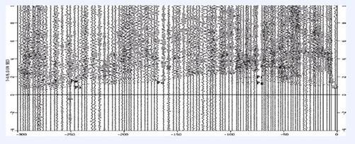
Fig. 10 – Wide-angle seismic record section from a shot in the Haiyuan region. 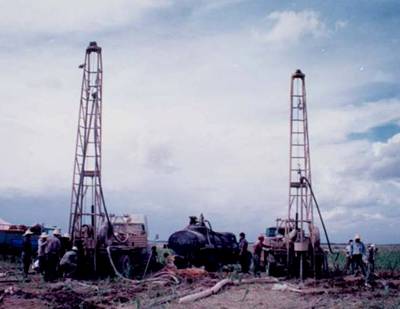
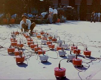
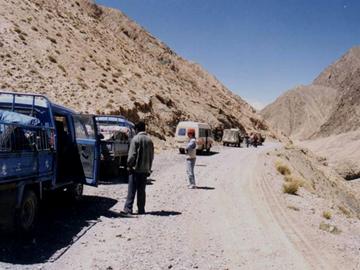
Fig. 11 – Shothole drilling and loading along seismic Profile 973. 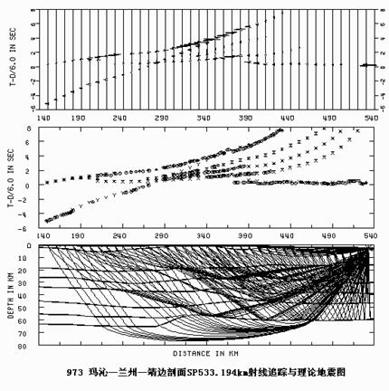
Fig. 12 – Example of ray-trace modelling of the P-wave velocity structure Fig. 13 – P-wave seismic velocity structure along Profile 973. The crust of the 1000 km long Profile 973 is well stratified into two primary parts: an upper crust and the lower crust, with interface "C" as the boundary. From NE to SW the crust gradually thickens, mainly due to increased thickness of the lower crust. At the same time, the average crustal velocity decreases and the number of crustal interfaces becomes greater. Those indicate the general trend of the crustal variation is: from NE to SW the crust becomes softer and softer, and more and more complicated. An important discovery was the very strong regional structural anomalies existing in Haiyuan and Maqin regions, including large offsets of the Moho, low-velocity layers, very low average-crustal velocities, complicated transitional zones at the Moho and C-boundaries. Seismic reflection profilingA second phase of the project focused on the triple junction region and included two seismic reflection profiles and four high resolution magneto-telluric sounding profiles. The transect extends southwest-to-northeast from the Sayan Kar Fold Belt of the Tibetan Plateau south of the Kunlun Fault, across the Qinling-Qilian and Helanshan fold belts, Haiyuan and Qinling Faults to the Ordos Basin (Fig. *). 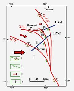
Fig. 14 - Location of seismic reflection profiling on the northeast margin of the Tibetan Plateau. 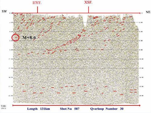
Fig. 15 – Seismic reflection profiling image of the Earth's crust 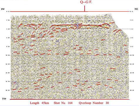
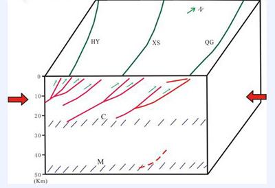
Fig. 16 – Seismic reflection profiling image of the Earth's crust The results from the deep seismic reflection profiling show the existence of a group of arcuate faults in the triple junction region, including Haiyuan Fault, Xiangshan North Margin Fault and the Quinling Fault. All the faults dip to the SW and penetrate to the deep crust. From SW to NE, the dip angle decreases gradually. It indicates the compressive action from the active and soft Tibetan Plateau to the passive and hard Ordos and Alxa Blocks.
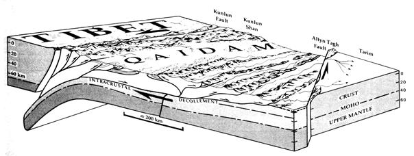
Fig. 17 – Interpreted crustal-scale faulting in the Haiyuan region derived from Various authors have made reconstructions of the fault structures on the northern and northeastern margins of the Tibetan Plateau. Figure 14 shows one conceptual reconstruction of crustal and upper mantle structures cutting the Kunlun Fault to the west of the present study area based on the interpretation satellite images of topography and fault reconstruction (Meyer et al., 1998).
Fig. 18 – 3-D block diagram sketching inferred crustal deformation AcknowledgementsThe compiler of this brief description freely acknowledges the copyright on the scientific papers by the authors attributed in the text and figure captions and of the publishers of these scientific papers. Text passages quoted and figures used from these papers are made within the "fair dealing& and the "fair use" provisions for "research and study" and for "criticism and review" within the copyright laws of Australia, other common law jurisdictions, countries of the European Union and the USA. Any copyright issues arising from this web page should be brought to the attention of Dr. D. M. Finlayson, Business Manager, IGCP Project 474. BibliographyAlsdorf, D., Brown, L., Nelson, K. D., Makovsky, Y., Klemperer, S. & Zhao, Wenjin, 1998. Crustal deformation of the Lhasa terrane, Tibet plateau from Project INDEPTH deep seismic reflection profiles. Tectonics, 17, 501-519. Chen, Z., Burchfiel, B. C., Liu, Y., King, R. W., Royden, L. H., Tang, W., Wang, E. & Zhang, X., 2000. Global positioning system measurements from eastern Tibet and their implications for India/Eurasia intercontinental deformation. Journal of Geophysical Research, 105, 16,215-16,227. Fan, J. Ch., Li, S. L., Zhang, X. K. et al., 2004. Geometric form of Haiyuan fault zone in the crustal interior and dynamics implications, ACTA Seismolgica Sinica, 17, Supp., 43-51. Hauck, M. L., Nelson, K. D., Brown, L. D., Zhao, Wenjin & Ross, A. R., 1998. Crustal structure of the Himalayan orogen at ~90o east longitude from Project INDEPTH deep reflection profiles. Tectonics, 17, 481-500. Hua-wei Zhou & Murphy, M. A., 2005 – Tomographic evidence for wholesale underthrusting of India beneath the entire Tibetan Plateau. Journal of Asian Earth Sciences, 25, 445-457. Li, S. L., Mooney, W. D., 1998, Crustal structure of China from deep seismic sounding profiles, Tectonophysics, 288, 105-113. Li, S. L., Zhang, X. K., Zhang, Ch. K. et al., 2001. Study on crustal structure in Haiyuan strong earthquake region. Earthquake Research in China , 15(3), 230-238. Liu, B. F., Li, S. L., Zhang, X. K. et al., 2003. Study of crustal structure with S-wave data from Maqin-Jingbian profile. ACTA Seismolgica Sinica, 16(1), 92-98. Meyer, B., Tapponnier, P., Bourjot, L., Metivier, F., Gaudemer, Y., Peltzer, G., Guao, S. & Chen, Z., 1998. Crustal thickening in Gansu-Qinghai, lithospheric mantle subduction, and oblique, strike-slip controlled growth of the Tibet plateau. Geophysical Journal International, 135, 1-47. Song Ruixiang (Editor-in-Chief), 2002. Album of the Kunlun Pass West Ms 8.1 earthquake. China Seismological Bureau, Seismological Press. Zhao, G. Z., Tang, J., Zhan, Y., 2004. Study on the relationship between crustal electric structures and deformation of blocks in northeastern margin of Tibetan Plateau. Science in China , Ser. D, Earth Science, 34 (10), 908-918. ContactsSonglin Li, Research Center of Exploration Geophysics, China Earthquake Administration (previously called the China Seismological Bureau), 104 Wenhua Road , Zhengzhou , Henan 450002, P. R. CHINA [email protected] Tel: (86) 371-6393-4547 Fax: (86) 371-6393-1341 Guoze Zhao, Institute of Geology, China Earthquake Administration, Beijing 100029, P. R. CHINA [email protected] Tel: (86) 10-6200-9065 Qiyuan Liu, Institute of Geology, China Earthquake Administration, Beijing 100029, P. R. CHINA [email protected] Tel: (86) 10-6200-9311 Fax: (86) 10-6202-8617 Photo Album
|
||||||||
| Disclaimer | Copyright | |||||||||