Crustal Architecture and Images

|
IGCP Project 559
Crustal Architecture and Images |
 |
|
contact us: [email protected] | about us
|
|
34rd International
|
Updated: Nov 20, 2008 COCORP startup: the first deep seismic profiling of the continental crust in USA, Hardeman County, Texas, 1975By D. M. Finlayson (Canberra) [email protected]BackgroundDuring the 1960's and 1970's the oil exploration industry was using seismic reflection profiling techniques extensively throughout the world in their quest to secure new oil and gas reserves. The reflection profiling technique for exploring sub-surface geological structures uses common-mid-point (CMP) seismic methods for data acquisition and image enhancement. http://www.litho.ucalgary.ca/atlas/seismic.html Generally the exploration industry only acquired seismic profiling data sufficient for the purpose of identifying and evaluating oil and gas accumulations within sedimentary basin sequences and thus recording times were commonly only 6 seconds or less. In the 1960's there had been reports from a number of countries (Germany, Canada, Australia, etc.) of seismic crews using extended recording times (up to 20 seconds) to record reflection data from within the basement rocks to the sedimentary basins. In some cases this produced images of geological features within basement rocks that were quite spectacular and geologically significant. This led eventually to the concept of using slightly modified oil industry seismic profiling techniques to systematically investigate the geological structure of basement rocks within the continental crust. In USA, Dix (1965) summarised some work done in the Mojave Desert to develop seismic reflection profiling techniques to investigate the deep crust. He was optimistic that the reflection profiling technique would eventually provide detailed geology not evident from other wide-angle seismic profiling methods. Most of the early deep seismic profiling in various countries used explosive seismic energy sources. The significant feature of program proposals in USA was to use VIBROSEIS seismic energy sources developed for the oil exploration industry. This method continues to be used with great success around the world for deep seismic profiling surveys. Oliver et al (1976) summarised the history of early seismic reflection profiling as follows:
Establishment of COCORPJack Oliver was appointed to the Chairmanship of the Department of Geological Sciences, Cornell University, in 1971 and focussed his research on continental geology, in particular the deep geology. In 1973 he received a small grant from the National Science Foundation to look at the feasibility of deep seismic reflection profiling as a means of investigating deep geology. At the same time he recruited Sid Kaufman to the faculty at Cornell following his retirement from Shell as the Senior Research Physicist and assistant to the Vice-President for exploration research. Larry Brown was the third member of the Cornell team at the time as an Associate Professor. At the Society of Exploration Geophysicists Annual Meeting in Mexico City in 1973, there was a special session that reviewed deep seismic reflection experiments from around the world. Subsequently proposals were made for the establishment and funding of the Consortium for Continental Reflection Profiling (COCORP) to the US National Academy of Sciences as part of the US Program for the International Geodynamics Project (COCORP Newsletter No. 1, Oct. 1976). These proposals were accepted and funding was then forthcoming for the first three COCORP projects from the National Science Foundation (NSF). COCORP was in business (Society of Exploration Geophysicists: Virtual Geoscience Center, 2005; http://www.mssu.edu/seg-vm ). The Executive Committee during these early days of COCORP was:
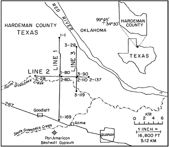
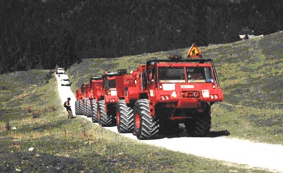
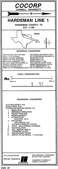
The Institute for the Study of the Continents (INSTOC), Cornell University, played a key role in initial planning and operations of COCORP and this has continued ever since these early days. The early COCORP organisation also had a Site Selection Advisory Committee, a Technical Advisory Committee and various sub-committees and correspondents. COCORP data are available to research groups via the COCORP web site: http://www.geo.cornell.edu/geology/cocorp/COCORP.html Hardeman County, Texas, deep seismic profiling, March, 1975COCORP deep seismic profiling operations in the Hardeman Basin during 1975 recorded data along lines totalling 36.8 km in length (Fig. 1). The site was chosen because there had been some extended recording done during routine exploration for oil and gas that indicated reflections from within the basement rocks were likely to result in a good demonstration of the VIBROSEIS technique for deep seismic profiling (Oliver et al., 1976). Petty Ray Geophysical, Inc., of Houston, Texas, was engaged for the data acquisition and computations. The field acquisition unit was a 48-channel MDS 8/Mandrel Data System; geophones were Electro Technical Laboratory EV22C with a natural frequency of 7.5Hertz; the VIBROSEIS technique was used, sources being five synchronized vibrators (three Y-1100, each of 13.5ton peak force, and two Y900, each of 10.5ton peak force). Two days were spent prior to production work to establish the field parameters. Studies of source generated surface and near surface waves were made using single location sources and podded geophone spreads. Various arrays of vibrators and vibrator signal frequencies were studied. The parameters chosen for the production work were the following (Oliver et al. (1976):
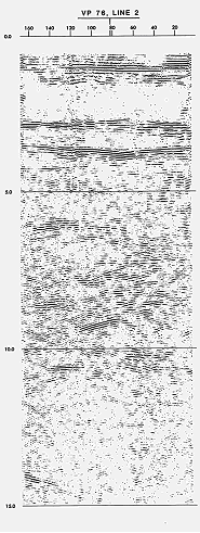
 Fig. 1 – Location of the COCORP deep seismic profiling lines  Fig. 2 – A 1990's version of the Failing Y-1100 seismic vibrator   Fig. 3 - Seismic record sections to 15 seconds two-way time (TWT)   Fig. 4 - Seismic record sections to 15 seconds two-way time (TWT) Oliver et al (1976) summarised the initial results from this first COCORP deep seismic profiling survey.
Lynn (1979) interprets the COCORP Hardeman County data as follows:
Brewer et al. (1981) interpret the Hardeman Basin results and adjacent COCORP data from south-western Oklahoma in the following terms:
However Miller et al (2001) suggest that alternative interpretations are possible.
Global significance
BibliographyBrewer, J. A., Brown, L. D., Steiner, D., Oliver, J. E., Kaufman, S., and Denison, R. E., 1981. Proterozoic basin in the southern mid-continent of the United States revealed by COCORP deep seismic reflection profiling. Geology, 9, 569-575. Clamming, G. L., and Chandra, N. N., 1975, Further studies of reflections front the deep crust in southern Alberta: Canadian jour. Earth Sci., v. 12. p. 539 557. Dix, C. H., 1965, Reflection seismic crustal studies: Geophysics, v. 30, p. 1068 1084. Dohr G., and Meissner, R., 1975, Deep crustal reflections in Europe: Geophysics, v. 40, p. 25-39. Fowler, J. C., and Waters, K. H., 1975, Deep crustal reflection recordings using "VIBROSE!S" methods: A feasibility study: Geophysics, v. 40, p. 399 410. Hasbrouck, W. R, 1964, A seismic reflection crustal study, in central eastern Colorado [PhD. thesis]: Golden, Colorado School Mines, 133 p. Junger, A., 1951, Deep basement reflections in Big Horn County, Montana: Geophysics, v. 16, p. 499 505. Kanasevvich, E. R., Clowes, R. M., and McCloughan, C. PL, 1969, A buried Precambrian rift in western Canada: Tectonophysics, v. 8, p. 513 527. Liebscher, H. J., 1964, Deutungsverche fur die Struktur de tiefen Erdkrust nach reflexionsseismischen und gravimetrischen Messungen im deutschen Alpenvorland: Zeitschr. Geophysik, v. 30, parts 1 and 2, p. 51 125. Lynn, H. B., 1979. Migration and interpretation of deep crustal seismic reflection data. Stanford University Thesis, 22 September, 1979. Mateker, E. J., and Ibrahim, A. K., 1973, Deep crustal reflections from. a vibratory source (abs.): Joint 43rd Ann. Internat. Mtg. Soc. Exploration Geophysicists and the 5th Mtg. Assoc. Mexicana Geofis. Exploration, Mexico City, Oct. 21 25, 1973, Program, p. 31 32. Meyer, R. P., and Gettrust, J. F., 1973, Feasibility studies for deep crustal reflection work [abs.]: joint 43rd Ann. Internat. Mtg. Soc. Expioration Geophysicists and S.th Mtg. Assoc. Mexicana Geofis. Exploration, Mexico City, Oct. 21 25, 1973, Program, p. 31. Miller, K. C., Eshete, T., and Smith, D. 2001. An overview of the seismic characteristics of layered sequencies of the Precambrian basement of the southern mid-continent. Abstracts of the Geological Society of America Annual Meeting, November 5-8 2001, Boston. Moss, F. J., and Dooley, J. C., 1973, Deep crustal and upper mantle reflection studies in Australia (abs.]: Soc. Exploration Geophysicists, Ann. Internat. Mtg., no. 43, p. 32 33. Narans, H. D., Berg, J. W., and Cook, K. L., 1961, Sub basement seismic reflections in northern Utah: Jour. Geophys. Research, v. 66, p. 559 603. Nelson, K. D., 1988. The COCORP Atlas. Institution for the Study of the Continents, Cornell University. Ithica, NY 14853, USA. Oliver, J., Dobrin, M., Kaufman, S., Meyer, R. and Phinney, R., 1976. Continuous seismic reflection profiling of the deep basement, Hardeman County, Texas. Geol. Soc. Am. Bull., 87, 1537-1546. Robertson, G., 1963, Intrabasement reflections in southwestern Alberta: Geophysics, v. 28, p. 910 915. Waters, K. H., and Fowler, J. C., 1973, Deep crustal reflection recording using Vibroseis methods: A feasibility study [abs.l: Joint 43rd Ann. Internat. Mtg. Soc. Exploration Geophysicists and 5th Mtg. Assoc. Mexicana Geofis. Exploration, Mexico City. Oct. 21 25, 1973, Program, p. 30 31. Widess, M. B., and Taylor, G. L., 1959, Seismic reflections from layering within the Precambrian basement complex, Oklahoma: Geophysics, v. 24, p. 417 425. Perkins, W. E., and Phinney, R. A., 1971, A reflection study of the Wind River Uplift, Wyoming, in Heacock, G., ed., The structure and physical properties of the Earth's crust: Am. Geophys. Union Geophys. Mon. 14, p. 41 50. |
| Disclaimer | Copyright | |